Tuesday, November 28, 2006

Now it's too hot

The weather certainly can change fast around here. Wasn't it just a few weeks ago that I was explaining (or complaining) about how cold it was, like the kind of cold that freezes the insides of your nostrils? The kind of cold that makes your eyes water and freezes the tears to your cheeks? I'm back in McMurdo now. We moved from mud season to flood season. The forecast high for today is +4C (which is about 39F). So for those of you who worry about me being cold in Antarctica, you can stop now. Don't forget that we have 24 hours of sunlight here too, so it really feels like summer. That will change, but for now it's nice. With all of this warm weather, it makes things logistically challenging because at this time of year all of the people and supplies come in on planes, and planes land on the sea ice runway and last year there was flooding on the ice runway and the roads on the sea-ice were a mess. I'll keep you posted on that. Here is a picture of the airfield today. There are a few planes (ski equiped LC-130's) parked there for the moment. They are probably waiting to fly to South Pole later today.
The station had an eerie look with ground fog from the evaporation of water from the roads and condensation in the air at noon today. I decided to take a look around because it was so nice. You can see Nik's white golf ball in this picture. That's the home of the antenna they use to track the polar orbiting scientific satellites. You can also see some of the large fuel storage tanks.
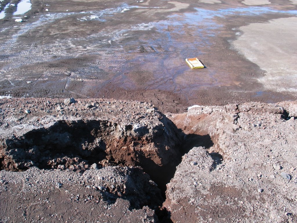
There has been significant stream flow now that it is warmer and that means erosion. The streams flow where they want to, frequently right through the station. The road out to Hut Point is not in danger of washing out any time soon, but I would advise you not to stand too close to the edge. This kind of thing happens every year. There are also ponds and pools of water in the low spots. They are constantly moving soil around here to grade the roads, improve drainage, fill the holes and so on.

Friday, November 24, 2006

Living next to Canada Glacier

I went to Lake Hoare again this week with my team members. We went on Tuesday afternoon. Monday had been a "no fly day" due to bad weather, so we didn't think we would be able to get out to the field on Tuesday as we had planned. The weather was fine on Tuesday and the helicopter coordinator was able to get us on the helicopter schedule, even though most of our gear came out on later flights. We had a strong tailwind, which made it a quick flight across McMurdo Sound. We arrived at Lake Hoare with our personal bags, tents, and sleep kits, but the science gear arrived later that night. One thing I have noticed about aqueous geochemists is that they often have bulky cargo for all of their empty sample containers. The field labs have limited storage and anything stored outside needs to be strapped down so that things don't get blown away by the katabatic winds. We set up a 50 cubic foot triple-walled cardboard box (50 cube triwall) and used a cargo strap to lash it onto the back on the chemistry lab. We filled that triwall with boxes of bottles and plastic containers, but we probably could have used a second 50 cube triwall because many of the bigger containers didn't fit. Let's say that our team is now known as "Max Cube". I think we have about 100 cubic feet of bottles, jars and carboys for our snow and water samples. Becki and Joel were very busy cleaning all of these bottles last week. They will be very busy with all of the sampling. I'll be busy soon analyzing all these samples.

One of the great things about being in the field is living with glaciers. Lake Hoare camp is next to the Canada Glacier. It provides a lovely backdrop to camp, it shelters us from some of the winds and it provides "glacier berries" that calve off of the face of the glacier. We collect these glacier ice chunks and melt them for our drinking water. The glacier ice is very clean and makes great tasting water. The glacier starts off high in the Asgard Range and flows to the south down to the valley floor. The cliff faces are about 50 feet high near the camp. They have some interesting features such as these "owls nests", cracks and some debris bands. It can be awe inspiring to stand this close to a glacier.
I slept in a Scott tent this time. Becki and I shared this tent because we had many people in camp and all of the other tent sites were being used. The Scott tent is very sturdy and easy to set up in strong winds. It is made of fabric, cotton I think, with thick metal poles. Here is a picture of our tent. It is very faded, but it works fine. It started its life as a sunflower yellow color and now it is more like vanilla pudding. The fabric is soft, so the inside of the tent is cosy and it doesn't sounds as crinkly and cold as the mountain tents. It is also tall enough to stand up inside, which does make it easier to put on pants.
Here is a picture of Lake Hoare, looking west to the Suess Glacier. Over these last few weeks since I was last there, the sun angle has changed significanly. The sun only sets behind the Asgard Range for a few hours every afternoon. The lake ice is becoming warmer. It is harder to get around on the ice because melt pools are forming. We had air temperatures a few degrees above freezing recently. Now that it is getting warmer here, things will start to change quickly, as ice changes to water.

Sunday, November 19, 2006

Not much news


This week has been a big week for "getting ready" again as members of the LTER stream team and geochemistry teams arrived in McMurdo and they have been gearing up for their field work. I've been helping with bottle washing, preparing lab equipment and answering many questions. One bit of excitement came on Saturday morning as word spread that there were penguins on the sea ice runway. It's not too uncommon to see penguins and seals out on the sea ice near station, and if you were a penguin, wouldn't you want to walk on the flattest and straightest path available? Even if a C-17 was about to land? Would an emperor penguin think, "that's a really big and obnoxious penguin and it can fly!" I don't have any new pictures for this post because the penguins were too far away, but I did see them from the Crary lab spotting scope. They were pushing themselves along on the sea ice on their bellies. Here is one of my older pictures of emperor penguins.
I will be heading out to the field again tomorrow, just for a few days. Although, the weather has not been very amenable to helicopter operations recently, so will wait and see what happens. It has been snowing a little bit every day since I posted "mud season", but there has not been much accumulation.

Tuesday, November 14, 2006

Mud season

Even though it is still below freezing here, it's officially mud season in McMurdo (or is that MuckMurdo?). It is -5C (23 degrees Fahrenheit) today and it feels warm, just like spring, but without the crocuses. The air temperature is still below freezing, but the dark roads absorb solar radiation and they are warmer than the air above. As the summer progresses, the snow continues to melt and the snow drifts get smaller, and crustier. Ya gotta love all of the changes that happen in McMurdo through the summer. That is Ob Hill in the background. "Ob Hill" is short for Observation Hill. I won't get the details exactly right without looking up the story, but one of Scott's parties was left in the McMurdo region and they spent the winter in a hut near here. Every day one of the members of the team would climb to the top of Observation Hill to see if a ship was returning to pick them up. These days, most of us come and go on planes, but Ob Hill is a great place to climb and take in the view.


Here is the road sign that marks the road that runs along the Crary Lab. It is affectionately called Beeker Street (you know, the muppet) and it may be the only street in town with a name. All scientists in McMurdo including biologists, chemists, geologists, glaciologists, and astronomers are called "Beakers". Some Beakers think this is very strange because they never use beakers. I am an aqueous geochemist, therefore I use beakers in my job on a daily basis. I work in the Crary Lab analyzing water samples from the glaciers, streams and lakes in the dry valleys, so I guess I really am a Beaker.

Monday, November 13, 2006

Getting out

On Sunday I took a break from working in the lab and went on a hike with Jill and Robin. We were skeptical about the weather forecast, but it turned out to be a gorgeous day. There is a sea ice route from McMurdo Station to Scott Base, the New Zealand base, and we are allowed to hike on this trail after attending the required Recreation Safety course. After filing our hiking plan with the dispatcher at the fire house, we proceeded on our walk. The walk is about 2.5 miles on the sea ice on a groomed and flagged trail. It's a great way to get out of McMurdo and take in the surroundings from a new perspective. In this picture, we are looking back towards McMurdo with Mt Erebus looming in the distance.

The sea ice is a flat white world and at this time of year the walking conditions are perfect. It's still cold, which translates to "dry". The snow gets packed by the winds and then it is sometimes eroded by the wind. Here is a picture showing what some of the snow looks like. It forms beautiful patterns, like dunes. It is hard to imagine the blue world underneath the ice. I'm sorry I don't have pictures to show you, but it is supposed to be some of the most spectacular diving in the world. Robin had just done her check-out dive the day before our walk and she reminded us of all the creatures living in the water beneath our feet including colorful sea stars, spiders, urchins, fish.

After walking out away from Ross Island for a while and enjoying the scenery, the trail turns back toward land we started to get closer to Scott Base. Near Scott Base, there are pressure ridges in the sea ice where it gets squeezed between the Ross Ice Shelf and the land. There are also some deep cracks in the sea ice marked by these black flags. Black flags on hiking trails in Antarctica indicate danger, so it's important to stay on the flagged route and watch your step near the transition between land and sea ice. Snow often covers these cracks, so it is not always possible to see the dangerous parts. The sea water below the ice is -2C, so it would not be fun to break through.

Scott Base is a research base in Antarctica, but in some ways it also feels just like New Zealand, except it is much colder. The New Zealanders (Kiwis) seem to love color, especially the color Kiwi green. All of the building on the NZ base are painted a bright shade of kiwi green. Most of the buildings are also connected by walkways, so it feels very cozy inside. There is a great little store at Scott Base and many people from McMurdo Station enjoy going over there to shop for souvenirs.

Dogs are no longer allowed in Antarctica by the Treaty, but the people at Scott Base have a mascot named Chloe to great us as we entered the main door of the station. In the past, the New Zealanders had dogs at Scott Base until some time in the 1980s. I suspect that they are missed by the current residents very much.

Scott Base is not far from McMurdo, but it has a different perspective of Ross Island, so three of the volcanic mountains of the island can be seen. In this picture we can see Mt Erebus, Mt Terra Nova and part of Mt Terror. After visiting Scott Base and shopping at the store, we proceeded back home to McMurdo Station. There is a road that connects McMurdo Station and Scott Base (and a handy sign to tell you the way). To get there you must climb up a long and steep hill. OK, I have really not done enough walking here this summer and most of my walking in Columbus is on flat trails, so it will take a while to get in shape for this Scott Base hill. I'll just have to keep walking.

Sunday, November 05, 2006

More algae

I had a question from Granny about the algae trapped in the ice. Here are a couple more pictures. The algal mats grow at the bottom of the lakes (and in the stream beds and practically anyplace where they can find liquid water). They are photosynthetic, so sometimes they get loaded with oxygen gas bubbles. Chunks of the mats get torn off and float up to the ice cover. They get trapped there under the ice. The top photo shows bits of algal mat that have worked their way to the surface of the ice on the moat near Lake Hoare camp. Each little bit of mat is followed by a bubble trail. Maybe the mat melted its way up through the ice by differential heating? It looks very strange.
The botton picture shows more algae chunks on the ice surface. I'm not sure how that happens exactly, but the lake ice acts as a slow conveyor belt moving things up as the ice surface is constantly ablated and new ice forms on the bottom of the ice. It probably takes at least a few years for the algae to make that trip through the ice.

Saturday, November 04, 2006

Avalanche

One thing I have noticed about Antarctica is that it is always surprising, but it is not usually startling. Every day something unexpected happens, but not usually in a hurry. On the day we walked to the end of Lake Hoare over towards the Suess Glacier, it was very still. We heard the crunching of our own footsteps and then quiet. Then we heard a distant rumble and noticed a cloud of snow coming from the ice falls on the Suess. It was far away, but still very distinct. We heard this happen several times and the snow cloud became more dense and started to slowly drift towards us.
It's hard to imagine what quiet sounds like. In our modern world at home in cities we have people, construction, traffic, and music playing in public spaces. Even in the wild there are insects buzzing and the sounds of the wind blowing through the trees. I have never experienced quiet like the quiet of the polar regions on a calm day.

Wednesday, November 01, 2006

Transition ice

Here is another picture from Lake Hoare. This is transition ice, the ice between the moat and center ice. This year there is snow on top of the ice cover which makes it hard to see. There is also sediment (sand) on top of the ice. Sometimes this sand looks like mini dunes. This sediment gets blown onto the lake ice during wind storms. As the ice warms, the sediment will melt down into the lake ice and form melt pools. For now, the sediment is a safe place to step. Even though I love ice, I do not always like walking on it, especially when it looks like this. I am now safely back in my lab in McMurdo, so I can enjoy the beauty of it and not have to work on it. The Suess Glacier is barely visible in the background.

I like ice

There is water in Antarctica, lots of it, but most of it is in solid form. I have a fondness for the ice, whether it's snow, glacial ice, sea ice, icicles hanging off the buildings, ice cores for research, or in this case, frozen lake water. The lakes in the dry valleys have a perennial ice cover and the ice surface has very strange looking ablation features. Around the perimeter of the lake, the ice melts during the summer from solar heating along the shore forming a moat. The moat is still frozen solid now, but in a few weeks it will start to warm and melt. It will refreeze again at the end of the summer. The moat ice looks different from the center ice on the lake. I have a few pictures of the ice on the moat near the shore of Lake Hoare. The color of the ice varies quite a bit depending on the light, the ice thickness, the water depth, the gas bubbles, trapped debris, etc. One of these photos shows some brown blobs which are chunks of algae that grow on the lake bottom and some of them get trapped in the ice. The gas bubbles sometimes look like fireworks stopped in time. The "blue" picture is thicker ice. It feels a little unnatural to walk on the ice when it is very clear and you can see to the bottom of the lake.

Our internet connection is pretty SLOW down here, so I have had a bit of trouble getting my pictures onto the blog. More to come later, I hope.